Sunday, March 29, 2015

The Steve and Marcia Jungle Trail

Most visitors to Corregidor are guests of Sun Cruises, which operates a daily ferry most of the year.  The guests are transported along the main roads, and are treated to sights of old buildings and a few of the Rock's gun batteries, as well as numerous monuments and the Malinta Tunnel complex.  We love -- and specialize in -- taking guests to more remote parts of the island.

As we prepare to move back to the United States, one legacy we would like to leave is a jungle trail that enables people to see the side of Corregidor we most often show our visitors.  We are happy to be working in cooperation with Sun Cruises to oversee and establish such a trail as a permanent offering.

We dedicate this guided tour posting to those of you who will never be lucky enough to hike the trail by yourselves.  But we also present it to whet the appetites of those of you who may have taken the regular Sun Cruises tour and now want to come back to see more, and also to first-timers who prefer hiking to spending your time on a motorized tour.

The hike takes about three hours, and includes passing directly through a 100-year old bunker, visiting several gun batteries, exploring two tunnels (for those who desire and are physically able), and opportunities to see any of the island's 40-plus bird species, along with other wild creatures from monkeys to lizards.

Note:  The photos used in this post cover several years of our using this trail.

We begin the hike near Battery Grubbs.  Here we see Marcia taking the short but steep approach to Battery Smith Tunnel.  Sun Cruises will provide ropes here and all along the trail to ensure safe descents and ascents.

Passing through Smith Tunnel often causes many of its swallows to take flight.  Here is a mother on her nest.  We're told that this is the source of "bird's nest soup."

This single gun is known as Battery Smith.  It was completed in 1921 at a total cost of less than $150,000.  Talk about inflation since then!  It is truly a magnificent sight, and one we will see again later on.  Look at the metal missing from the end of the barrel, which we use to verify its identify from afar.

 Chances are pretty good that sometime on your visit to Corregidor you're going to see one or more Philippine long-tailed macaques.  They live in tribes of thirty to fifty, and we believe that there are no more than ten tribes on the island.  Still, three to five hundred monkeys is more than enough for an island barely two and one-quarter square miles.

This mangrove blue flycatcher is seen perching on a vine inside the remains of a 50 foot deep mobile-gun shelter near X-F-1.  A complementary shelter can be seen on the other side of Battery Hanna; we are also aware of a pair of similar shelters bracketing Battery James.  Unlike the guns at the fixed batteries, these 155mm guns could be hidden inside the reinforced concrete roof and sides, dirt floor, and wooden door.

Usually called part of Battery Hanna, this is actually the location of X-F-1 (Sector 10, Field Gun #1).  As far as we know, it had no guns mounted during WWII but may have been used for storage and shelter. It was completed in 1914, over 100 years ago.

Here is the entrance to the tunnel under X-F-1.  Currently it is unsafe to enter, as the wooden ladder has become termite food.  A new ladder will be installed soon.  The tunnel is fairly large and has long, square-walled passageways which indicate that it was constructed by American soldiers before their capture in May, 1942.

However, as you can see, characters scratched into one dirt wall indicate that Japanese soldiers used the tunnel during their occupation of Corregidor.   We are told that the only clearly recognizable character is "10," and possibly the ancient form of the number two.

 
Conchita Island as seen from the remaining emplacement of Battery Hanna, completed in 1919.  You are actually on a balcony built out over the cliff.  The partner balcony for another 3 inch field gun was off to the left and has long since fallen off the cliff.  The pair were used to protect nearby searchlights.

This is a closeup of some very pretty seaweed growing 240 feet below Hanna.

Here you can see a pair of Philippine serpent eagles circling overhead, probably looking for serpents, or fish if they can't find serpents.

We've seen a couple of pythons on this path.  As you can see, pythons are beautiful.  Rest assured that they are non-venomous, so although they may look scary, they are sights to behold.

We've taken many visitors on this trail over the years.  Our most recent guests were Tom and Sylvia from Washington State, and Lhen and Earl, from Laguna, Philippines, and Texas, respectively.  This is one of our favorite photo ops, since walkers can literally pose under the trunk of this banyan (balete) tree.
 
The barrel of Battery Smith as seen from across Cheney Ravine.  The damage to the barrel end is unmistakeable.  Although this is a telephoto shot, the gun is easily visible with the naked eye, since the distance across the ravine is nowhere near the distance walked on the serpentine trail.

Last year's eagle nest is easily seen, and we are hoping that the mated pair either chooses the same nest again (we don't know if they do that) or chooses to build one where we are fortunate enough to once again watch the eaglets.

Marcia took this picture last year near Battery Cheney.  It is one of the adults from the white-bellied sea-eagle nest above.

After coming back up Cheney Ravine you arrive at Battery Cheney, which was completed way back in 1910.  Gun specs: two 12-inch Model 1895, with Disappearing Carriage, Limited Fire, Model 1901.  Construction material was Portland reinforced concrete.  Interior rooms include two each shell and cartridge rooms, and one power room, motor generator room, store room, and guard room. Cost of construction $267,200This battery was also the power source for Searchlight #4.

This is one of the most scenic spots on Corregidor.  On a good day you can see all the way to Mindoro.  On the far left is Searchlight Point, with Searchlight #5, then a point with no apparent name (the two points almost appear as one in this photo), and on the far right Wheeler Point with the aforementioned Searchlight #4 and Battery Monja.

In February, 1945, a fierce battle near the top of this cliff lasted less than three hours and resulted in the deaths of more than 250 Japanese who had charged the area.  The dead bodies were disposed of by throwing them over the cliff, leading people later to assume that these Japanese had committed suicide.  It is wrongly referred to as Suicide Cliff, and is more appropriately called Banzai Cliff.

NOTE:  There are no "suicide cliffs" on Corregidor.  Japanese soldiers did not jump off cliffs to commit suicide, which would have been considered dishonorable in their code.  However, on other islands such as Saipan, civilians, especially women and children, committed suicide by jumping off cliffs because of what they had been told that the American soldiers would do to them.

Looking down Banzai Cliff you can see a Brahminy kite sitting on its nest.  This is the second year in a row that kites have used this nest.

One of the real treasures of Corregidor, and one we hope more people will be able to visit once the trail is put into regular use, is Wheeler Tunnel.  Here's Marcia about to go into the entrance, which is naturally camouflaged on the side of a cliff.

Once inside you find a concrete-lined storehouse, with two sets of stairs that look like they could have been built in the past year.  There do not seem to be official records for the tunnel, but unofficial sources indicate that Fort Mills commander Brig. Gen. Charles Kilbourne had it built around 1930.

With patient searching you're bound to see one or more African cave spiders, also called tailless whip scorpions.  Scary looking as anything, they are harmless to humans.

Here is Marcia climbing out the alternate exit to Wheeler Tunnel on very old but still very reliable iron ladder rungs built into the concrete vertical shaft.

After exiting Wheeler Tunnel we soon come to Battery Wheeler, very similar to Battery Cheney with one exception: this disappearing gun battery had a gun DISAPPEAR!

The bottom level of Battery Wheeler, where the shell, cartridge, power, motor generator, and store rooms are located.

On occasion we've seen a monitor lizard on the trail between Battery Wheeler and the row of senior officers housing.

The is the house nearest the old Spanish Flagpole.  It has two stories, each with identical floor plan except for where the entryways are located.  Each has an open veranda around three sides, plus three bedrooms with closets, three bathrooms, two servants' quarters, dining room, living room with fireplace, pantry, storeroom, drying room, and kitchen.

We've had rave reviews from  people who have taken this tour with us.  We certainly love it, and hope that Sun Cruises will make this a permanent offering in addition to their standard day tour.  Hikers, historians, explorers, birders, and second time visitors will surely appreciate the experience.  Look for it soon from Sun Cruises, Inc.!
For those of you who can never take this tour, we hope that this gives you an inkling of the wonders of the history and nature found and preserved on Corregidor.  This posting is no substitute for the real deal.
We wish to thank good friend and Corregidor expert John M. for providing much of the technical details about the guns and tunnels.
Steve and Marcia on the Rock

Sunday, March 22, 2015

The Banaue Rice Terraces at Batad

As promised, here is the story of our tour of the Banaue Rice Terraces at Batad.

The rice terraces were built by the indigenous mountain people about 2,000 years ago.  In comparison to the vast rice fields in the provinces north of Manila, these are very small, only producing enough rice to feed the locals.  Unlike some areas where rice can be grown twice or even three times a year, Banaue rice is grown only once.  We were lucky to come early in the growing season, which will end around June; the rice will then turn golden brown and be harvested.

We got up early because of the long hikes ahead of us.  Some people told us that Banaue is as cold as Baguio in the morning, while others correctly noted that it is lower (3,700 feet vs a mile) and therefore usually warmer, although much more moderate than most of the Philippines, including Corregidor and Manila.  Pants and long-sleeve shirts were not needed after all.

The trip consisted of a jeepney ride as far as the road would take us, followed by lots of hiking.  We had to get down to the Banaue barangay of Batad, which is mostly on a hillside.  It consists of a small commercial area at the top that we'll refer to as "upper Batad," the main part of the village that is on a steep hillside, which we'll call "middle Batad," and a small part in the center of the lower rice fields, which we'll call "lower Batad" for lack of better terms.  Once we saw what we came to see, we had to walk back the same way we came.

Sunrise

 
Digital cameras have difficulty shooting directly into the sun, so this isn't exactly what we saw from our room in the Banaue Hotel, but it comes pretty close.

From Banaue as far as the road would take us...

Before we began our hike we had a one-hour jeepney ride to a drop-off point above Batad.  The guide asked the driver to stop several times so that we could see other terraces along the way.


Really young seedlings.  The rice is sown and harvested entirely by hand.


Many older people in the Philippines have a permanent stoop due to the constant bending required to plant and harvest rice by hand.

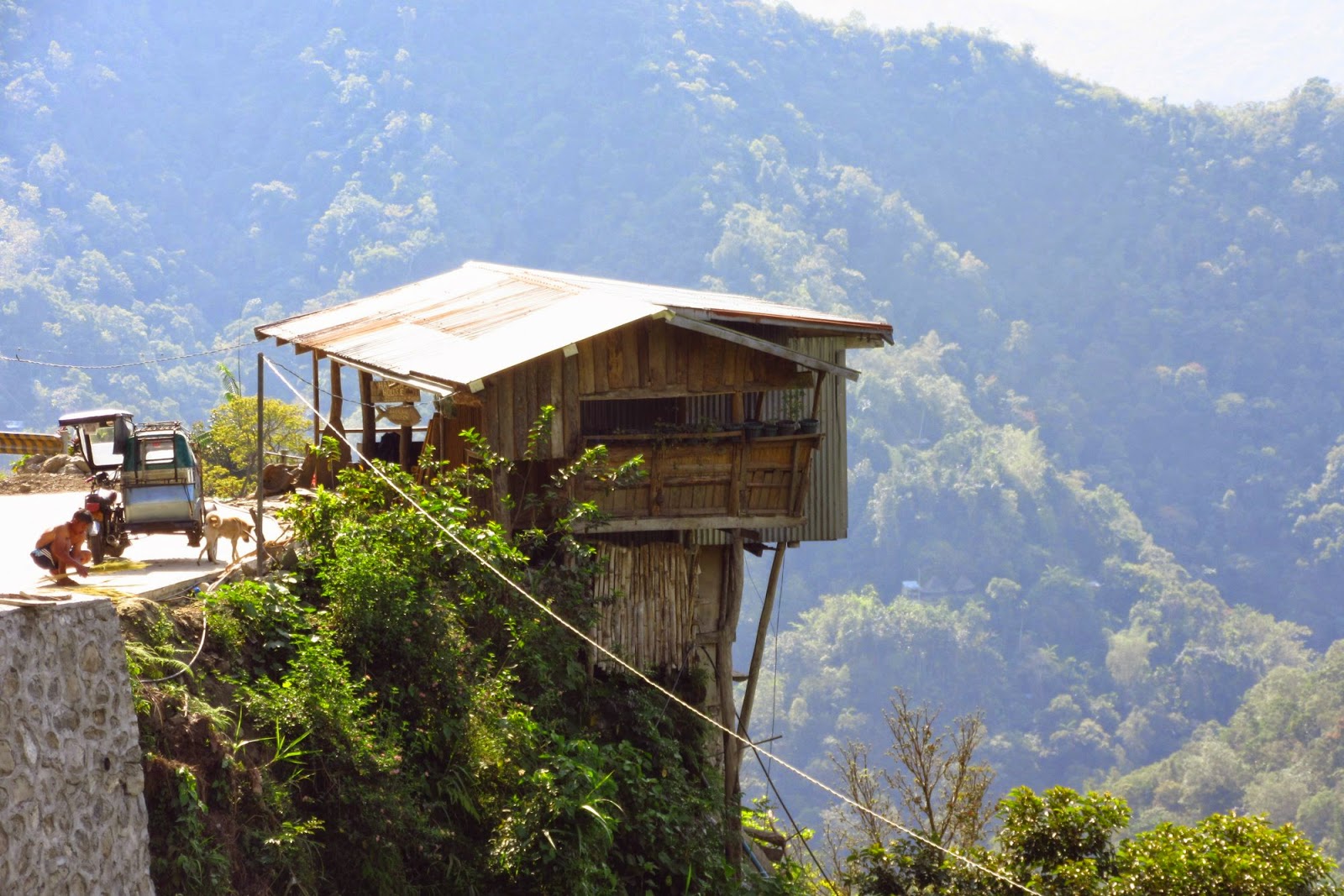
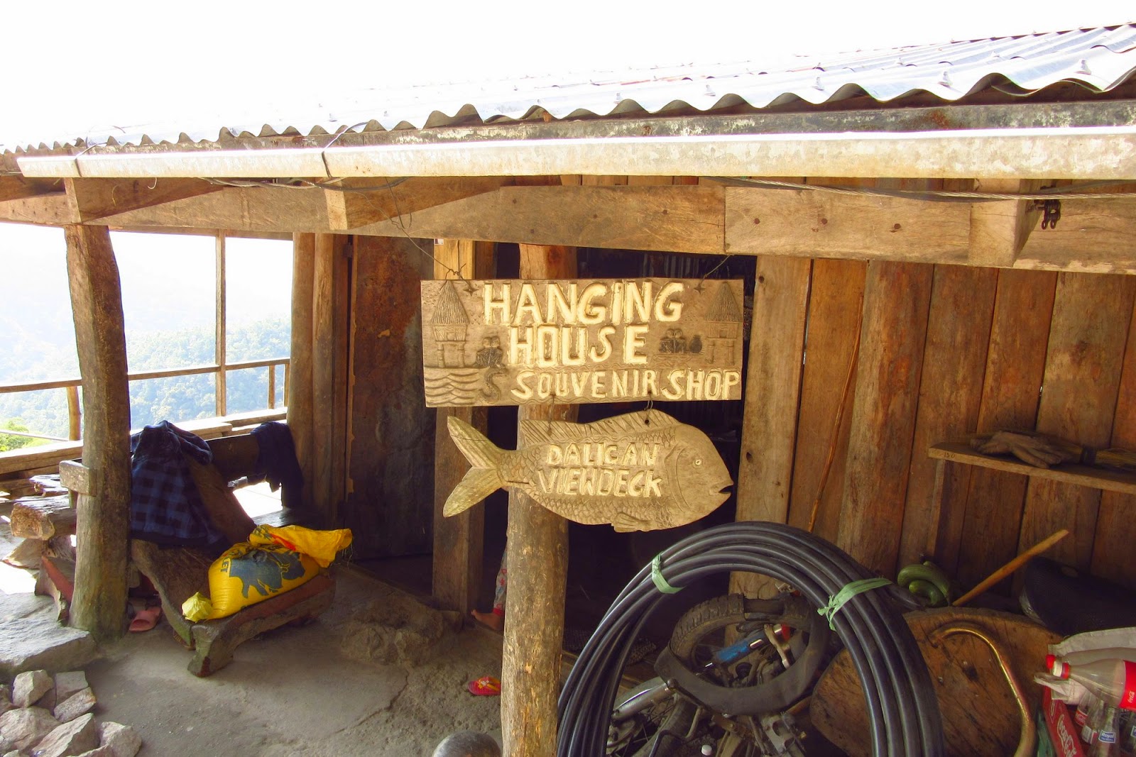
The "Hanging House"


Steve with a very special little girl named Nancy, whose family lives in the Hanging House.  Nancy was exceptionally friendly to Steve, who probably scares lots of Filipino children because of his height and their natural shyness.

From the drop-off point to upper Batad

The jeepney driver drove as far as he could, and further than the jeepneys have been able to go in the past.  Nevertheless, we had a long downhill hike ahead of us.  This is our first view of Batad and the rice terraces, way off in the distance.  Don't worry, we'll show you much closer views soon.  Center left is a road project.
 
Telephoto view of the road construction project we were soon to pass on our way down to Batad

For a short time we were able to walk on the new concrete road, which is very steep here, so steep that the jeepneys usually stay at the top of the hill.


One of the rock walls we talked about in our last post.  By the time this road is completed, there are going to be a whole lot more of them.

We've now walked down to the excavation site and are looking back at our starting point, realizing that later, when it's hot and we've walked a lot further, we have to trek back up.  If you look closely in the center of the photograph you can see a very large rock wall, the same one as in the previous photo.  How do they do that?

Digging away the side of the hill to continue the road in the same as the ancient walking trail that we are about to enter.

Hi ho, hi ho, it's down the trail we go.  In front, our guide, Jun.  Next, in green, Marcia.  Then Mike, and finally the photographer, Steve.  Since Steve is "bringing up the rear," a lot of shots will include just that.

At this point, quite a ways further down the trail, Steve was wondering if one of the signs said, "I'd turn back if I were you!"  Mike was reminded of a line from Dante's Inferno: "Abandon hope, all ye who enter here."

A carrying device consisting of a pole with two baskets that is used to transport supplies to the village of Batad, which as you know by now has no road.  Everything is brought in by foot.

The older indigenous people believe that having their photographs taken will steal their souls, so Steve always asked permission to take pictures of people.  These kids weren't shy.

Looking at one of the terraces across the valley, not yet down to Batad.

A telephoto shot.  By this point we are wondering how the workers got from level to level.  We were soon to find out. 

The view from upper Batad


Our first glimpse at a part of the "amphitheater" of the Batad terraces (from center to upper left)

Guide Jun as we arrive above the terraces.  The sly look on his face may be indicating that he's thinking, "You ain't seen nuttin' yet!"

The left side of the amphitheater
The center of the view from the top.  The right side, which is what we first saw from above, is not visible from this lookout point.  Even though the opposite side is far away (a mile or more?) Steve could not come close to getting the whole view in one frame, which really goes to show just how large this area is.  We are currently in upper Batad.  Lower Batad can be seen in the bottom left of this photo.

Descending through middle Batad

We begin our descent through the part of Batad that sits on a hillside.  Can you see how steep this is?

Houses, some thatched, much like what we saw at the Bontoc Museum the day before, and others with corrugated roofs.

Down, down, down we go.  Notice the flame tree in the upper right, according to Jun these are relatives of the ones we are used to seeing on Corregidor (poinciana), which don't bloom here until May.


This is the first time that we are walking along the top of a terrace wall.  One false step to the left means wet feet, to the right means taking the plunge.


The protruding stones just left of center form the "stairway" we just went down.  Not nearly as intimidating as when you look at them from above.  One slip and you're in a rice paddy up to your ankle in muck.  Jun called this a "hanging ladder."

Did we mention it was steep?  At the top of the hill where we left the jeepney vendors rent walking sticks for ten pesos apiece, the best twenty peso investment Steve and Marcia ever made.

+
Planting something other than rice, Jun said it was beans, which would later climb the existing plants.

Finally at the bottom, walking across to the other side


We're now down to the bottom and are about to walk across to the other side, passing through lower Batad along the way.

Wide "tightrock" walking

Looking back toward middle Batad

Looking to the right...

...and further right

Entering the part of the barangay that's in the middle of the fields, which we are referring to as lower Batad

Chicken coop

Inside, each basket is for one hen and her chicks

We let a group of younger people pass us while we rested.  A minute later, Steve would misstep and plop his left foot in the paddy about where the woman on the right is standing.

Another hanging ladder, much easier to ascend than descend

Looking back

Looking up.  We don't know how many levels there are, but there are a lot!

We've almost reached the far side now


Starting the ascent to the stairs which lead to the waterfall


We've now started ascending the other side, the purpose of which is to reach the path which leads down to a waterfall.

This is a good photo to show where we have been so far.  We started at the top (upper), just left of center, descended through the village on the side of the hill (middle), and walked across the bottom through the more concentrated residential area (lower).


When the guide tells us that the path to the waterfall is even narrower and steeper than what we are currently attempting, we decide to turn around.  After all, we still have to make it all the way back to where we started, and knowing that our legs are already feeling like Jello, we decide to head back.  Let the younger folks go for it.

Steve took this picture to try to show a "stairway" but it does a better job of showing his two shoes, the left one soaked in mud from his previous misstep.  And where the heck is the stairway?  We did not actually go down these stairs, we just wanted to show you what the local terrace workers use regularly.

We wonder if this little girl appreciates how easy she has it?


Back across the bottom, and starting back up

Back across the lower levels.  Germaine, Rita's daughter, is looking for us so she knows when to begin cooking our chicken, chicken, and chicken viands.


And back up we go...

A flower along the way.  Jun said it is in the poppy family.  Jun is a specialist in herbal plants and local medicines.

  Upper Batad for lunch


For you puppy lovers.  These belonged to Rita the restaurant owner, and were the sweetest little puppies when they woke up.  Later the mother laid next to Steve's feet and he could hear the slurp, slurp of the puppies feeding.

A postcard of the waterfall we didn't attempt to get to.  As pretty as it is, we are not sorry that we turned around when we did.  Even from the restaurant in upper Batad we still had to climb all the way back up to the jeepney.

Jun eating chicken adobo.  We also had the adobo, along with chicken curry and a soup called chicken tinola.  All three of these have become favorites of ours in our six-plus years in the Philippines.

A couple of cuties at the restaurant.  Through the miracle of modern science, Steve was able to show them the photo immediately, to their delight.

Marcia, Mike, and Steve with the Banaue Rice Terraces of Batad way down the hill in the background.  We're rested and ready to head back up.  Above Mike's head is the stairway we began to climb before turning back.  Falling onto Steve's cap is a landslide, not a waterfall.

Back up to the jeepney

These are the same terraces we saw on the way down, but now the lighting is better.

These men have just passed us and are delivering supplies to Batad.  They would not permit Steve to photograph their faces.

We're finally back to the pavement.  This is the rock wall that extends way down the hill.

The last leg.  Steep!

Our jeepney driver Ben as we head back to the city of Banaue.  Marcia sat up front while Mike and Steve rode in the back with some students who asked if we could give them a ride, it being Sunday.  They were returning from their remote homes back to their schools in the city.

On the way back up through middle Batad, Steve took a short video of the entire amphitheater and posted it on YouTube.  The video should give you a better idea of the vastness of the terraces in Batad.  While Steve was recording, Jun was giving Marcia an herbal recipe for treating high blood pressure using the young fruits of the wild sunflower plants that you can see at the end of the video.
https://www.youtube.com/watch?v=xy3GvLUdF7w

Truly a fantastic day.  This is rivaled only by our trip to Mount Pinatubo shortly after we moved to the Philippines.  And a great beginning of the end for our six-and-a-half-year stay in the Philippines.

If you never saw or want to revisit our Mount Pinatubo adventure in early 2009, go to:
http://steveandmarciaontherock.blogspot.com/2009/02/mt-pinatubo_12.html
Or you can look at the majority or the Mount Pinatubo photos at:
http://picasaweb.google.com/steveandmarciaontherock/20090210MtPinatubo#

Steve and Marcia on the Rock