
We drove out to the far east end of Kindley Field, a seldom-used 2400 foot grass runway, to begin our trek through the jungle. Not pictured: Steve the photographer and Jung Jung, whom we hired to lead us through the jungle and high grass.

Our first stop was one of the old civilian cemeteries. Here Len and Marcia are clearing leaves and debris to expose a grave marker.

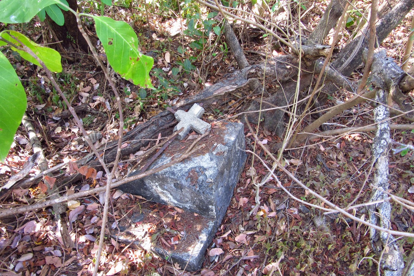
Marcia, resting and looking at the grave. She could not find any words, and the pieces of the concrete cross were scattered about the area. We find it sad that these graves lie unmarked amidst the jungle vegetation.
A cross at one of the small graves that most likely holds a baby's remains.

Yet another grave.

Steve resting by a small grave. It appears that originally there were two angels or cherubs, so we wonder if the grave held more than one child, or if the angels marked a family plot.

Another grave, and again, no identity.

Here is a cover for a concrete vault, maybe displaced by the war?

Jung Jung found this cross, separated from the grave it marked.

Jung Jung with the cross, Len and Marcia looking on as he moves it back to the grave site.

Sylvia and Tom present Steve and Marcia with Captured Honor: POW Survival in the Philippines and Japan, by Bob Wodnik. The book sparked Tom's interest and was his reason for searching the cemetery area. Washington State University Press asked Tom to review the book.

We are approaching a long, concrete wall, visible at the center of the photo. (Look in between Jung Jung's blue shirt on the left, and Earl's bright blue shirt on the right.) Sources say it is the remnants of the cemetery chapel.

The wall from the other side.

Jung Jung leading the way through the very tall grass. There are places where this grass grows as tall as Steve; 6' 5"

Concrete, indicating that a small building used to stand here. Maybe a lookout post?

A view westward, toward the "head" of the island as it curves to the left.

A hole into a very small room or bunker.

Looking inside. Not much to see, although there were three shed snake skins nearby, so maybe it's good that we didn't see anything staring back up at us! There are few such indications of fixed American defensive positions of any kind east of Kindley Field.

We are now approaching the tip of the tail, seeing signs of a recent fire in the area.

Oh yeah, there was a fire alright. In fact, from here to the east end almost all grass has been burned away. Thank goodness it stopped before it headed further west.

That's Caballo Island in the upper right.

Looking down along the north slope.

Caballo Island again. It's actually the other side of the caldera - the volcanic crater formed by the eruption of the ancient mountain, eons before the Spaniards came and called it "Corregidor." This is why today's Corregidor Island is arc-shaped.

Another look back toward the "head."

At this point your trusty photographer, Steve, has gone on ahead and climbed down to the south shore to await the others. It is a more difficult descent this time, because of the grass being burned away. A fistful of this grass can act as a good handhold.

Here come the others, carefully making their way down. We have to come down at this spot, before reaching the very tip of the island, because the last section of the ridge is too narrow and shear to safely walk along.

This beach is rocky but the rocks are not very large so it's still easy to walk.

Someone amassed a few nice seashells.

We're farther to the east, and now the rocks are getting much bigger in places, making it more difficult to walk without falling.

Farther east...

Looking west again, back towards the "head."

Nearing the east tip, and looking across to Caballo.

Some people like to pile up rocks, making carefully engineered stacks. Here is a simple one, more colorful than the camera shows, and if it symbolizes something we don't get it. Sort of resembles a bird with the beak to the left.

For most of the walk along the south side it is easier to walk on top of the accumulated trash than to try not to fall off the rocks. Zero percent of this trash originated on Corregidor. We have the metropolis of Manila to thank for most of it.

Another nice view of Caballo.

Tom and Jung Jung making their way to join Steve at the eastern tip.

Hooker Point (or Razor Island) off in the distance.

Hooker Point. At extreme low tide (which does not happen very often) it is possible to walk across on the barnacle-covered rocks. Because it is not super-low tide, we don't go across. It's not worth the risk to our cameras and cell phones.
 This picture, which we use at the top of each newsletter, is actually a
series of shots that Steve took when he was at Hooker Point on January 30, 2006, and then stitched together on the laptop. At this point in our current narration, however, we are standing on the beach below the high peak you can see on the right side, just left of the cliff in this old panorama.
This picture, which we use at the top of each newsletter, is actually a
series of shots that Steve took when he was at Hooker Point on January 30, 2006, and then stitched together on the laptop. At this point in our current narration, however, we are standing on the beach below the high peak you can see on the right side, just left of the cliff in this old panorama.

A nice rock formation unless you can see the monster's face carved by nature.

Tom coming around the corner, with the shovel and a bamboo pole for his staffs.

Another look at Hooker Point. Note the waves breaking across the sometime land bridge.

Now we're on the north side beach, extreme east end of the tail, and it is not so rocky. What looks like sand is actually crushed seashells.

Looking back at Jung Jung, who has picked up some rope discarded from a ship, Tom and Marcia, who are picking up pretty seashells, and our last view of Caballo.

We start our walk back along the north shoreline, taking one last look at Hooker Point. Marcia and Steve can't help wondering if they'll ever see this beautiful spot again.

A look forward (west) along the north beach.

Notice the evidence of a recent fire, and the high-tide line of trash from Metropolitan Manila.

A look up the sandy, ashy hill. But for the palm fronds, it would look like a desert.

Again, looking back. The beach has a sand path here, much easier to traverse than the south side.

Someday that leaning rock up there is gonna come a tumblin' down.

Real easy walking here.

A look north at a passing ship, on its way to the Port of Manila.

We're now to the place where we can head up from the beach and onto the grassy, jungled ridge-line from which we came.

.Jung Jung's piece of rope comes into play to help us safely back up the hill. He was obviously planning ahead.
.
Earl and Tom take a rest on the way back.
A fun but somewhat difficult hike due to the jungle, rocky beach, and heat, but definitely worth doing at least once. We hope that adventurers will continue to be able to experience it in the future.
Steve and Marcia on the Rock

No comments:
Post a Comment